Definitions[]
The global positioning system (GPS) is
| “ | a satellite-based technology that reveals information about the location, speed, and direction of a targeted subject. While it was initially developed for the U.S. military, countless civilian applications of GPS have appeared in the marketplace.[1] | ” |
| “ | a constellation of orbiting satellites that provides navigation data to military and civilian users around the world. These satellites orbit the earth every 12 hours, emitting continuous navigation signals. With the proper equipment, users can receive these signals and use them to calculate time, location, and velocity.[2] | ” |
| “ | a space-based radio-positioning system nominally consisting of a minimum of 24-satellite constellation that provides navigation and timing information to military and civilian users worldwide. GPS satellites, in one of six medium earth orbits, circle the earth every 12 hours emitting continuous navigation signals. In addition to the satellites, the system consists of a worldwide satellite control network and GPS receiver units that acquire the satellite's signals and translate them into precise position and timing information.[3] | ” |
Overview[]
The satellite-based Global Positioning System (GPS) is a U.S. Government-owned utility that provides users with positioning, navigation, and timing (PNT) services. The U.S. Space Force operates the space and control segments, consisting respectively of the GPS satellite constellation and the worldwide control stations that maintain the satellite orbits and adjust the satellite clocks. The U.S. government has invested more than $5 billion since 2009 in GPS and provides GPS service free of direct charge to users worldwide.
The GPS system consisting of space, ground control, and user equipment segments that support the broadcasts of military and civil GPS signals.[4] Each of these signals includes positioning and timing information, which enables users with GPS receivers to determine their position, velocity, and time 24-hours a day, in all weather, worldwide. GPS equipment is used on aircraft, ships, and land-based vehicles, and mobile hand-held units provide individuals with these capabilities as well.
GPS produces latitude/longitude coordinates by relying on established trigonometric principles, timing, range measurements, and several statistical models. Analogous to traditional land surveying, GPS requires a minimum of four simultaneous satellite observations to precisely position a point on the earth. By recording signals from at least four of the satellites, a GPS receiver is able to determine the X, Y and Z coordinates of the receiver anywhere on the earth's surface or on an aircraft. Since 2000 almost any GPS receiver is able fix a location within a few meters of its actual location.[5]
Initiated as a test program by the Department of Defense in the early 1970s, the Global Positioning System has provided positioning, navigation, and timing (PNT) data for military and civilian applications since 1992.[6] The system uses 24 satellites that orbit the Earth at an altitude of 10,900 nautical miles, portable or vehicle-mounted GPS devices receive signals from the satellites and calculate the user's position. GPS operates 24 hours a day, can serve an unlimited number of users, and operates in all weather conditions. The United States provides GPS data free of charge.
GPS began operations with a full constellation of satellites in 1995. Over time, GPS has become vital to military operations[7] and a ubiquitous infrastructure underpinning major sections of the economy, including telecommunications, electrical power distribution, banking and finance, transportation, environmental and natural resources management, agriculture, and emergency services. GPS is used by all branches of the military to guide troop movements, integrate logistics support, enable components underlying battlespace situational awareness, and synchronize communications networks. In addition, U.S. and allied munitions are guided to their targets by GPS signals and GPS is used to locate military personnel in distress.
Policies and directives[]
Various policy directives have assigned GPS governance roles, and other policies and directives apply to critical infrastructure protection that are important for GPS governance. These policies and directives include: (1) National Security Presidential Directive 39, (2) Homeland Security Presidential Directive 7, (3) the National Infrastructure Protection Plan, and (4) Presidential Policy Directive 21.
| “ | Prior to 2000, GPS used a system called "Selective Availability" that provided civilian applications with a degraded signal with lower accuracy than the military-grade signal. In May 2000, an executive order by President Bill Clinton[8] ended Selective Availability and provided civilian users the same quality signal as military users.[9] | ” |
GPS usage[]
| “ | GPS was introduced to personal vehicles in 2001 with in-car navigation devices and has since become a fundamental part of the transportation infrastructure. GPS assists drivers while providing large-scale information to technology companies and cities about transportation patterns. Widespread adoption of smartphones with GPS technology further increased connectivity and the amount of location data shared by individuals.[10] | ” |
Civil agencies, commercial firms, and individuals use GPS and GPS augmentations[11] to accurately navigate from one point to another. Commercial firms use GPS and GPS augmentations to route their vehicles, as do maritime industries and mass transit systems. In addition to navigation, civil departments and agencies and commercial firms use GPS and GPS augmentations to provide high-accuracy, three-dimensional positioning information in real time for use in surveying and mapping and other location-based services.
The aviation community worldwide uses GPS and GPS augmentations to increase the safety and efficiency of flight. GPS and GPS augmentations are also used by the agricultural community for precision farming, including farm planning, field mapping, soil sampling, tractor guidance, and crop scouting; the natural resources management community uses GPS for wildfire management and firefighting, pesticide and herbicide control, and watershed and other natural resources asset management. GPS is increasingly important to earth observation, which includes operational roles in weather prediction, the measurement of sea level change, monitoring of ocean circulation, and mitigation of hazards caused by earthquakes and volcanoes.
GPS helps companies and governments place satellites in precise orbits, and at correct altitudes, and helps monitor satellite constellation orbits. The precise time that GPS broadcasts is crucial to economic activities worldwide, including communication systems, electrical power grids, and financial networks.
GPS is used by both carriers and non-carriers to determine a device's location. GPS technology is based upon satellite signals, which are picked up and interpreted by devices equipped with GPS receiver chips. The device then measures the time it takes for it to receive various satellite signals and triangulates its location. Triangulating GPS satellite signals can yield data accurate to within 10 meters.[12] "The receipt of four signals provides enough information to solve for the location of the receiver and the time offset of the local clock."[13]
"GPS is used by all branches of the military to guide troop movements, integrate logistics support, and synchronize communications networks. In addition, many U.S. and allied precision-guided munitions are directed to their targets by GPS signals."[14]
GPS system description[]
As shown in figure 1, GPS operations consist of three segments — the space segment, the ground control segment, and the user equipment segment. All segments are needed to take full advantage of GPS capabilities.
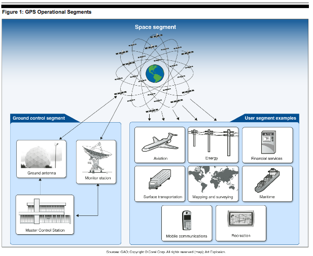
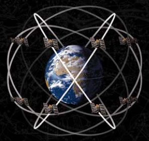
Space segment. The GPS space segment is a constellation of satellites that move in six orbital planes approximately 12,500 miles above the earth. GPS satellites broadcast encrypted military signals and unencrypted civil signals. The baseline constellation consists of satellites occupying 24 orbital slots — 4 slots in each of the six orbital planes. However, because the U.S. government commits to at least a 95% probability of maintaining this baseline constellation of 24 satellites, the typical size of the constellation is somewhat larger. Moreover in recent years, because numerous satellites have exceeded their design life, the constellation has grown to 31 active satellites of various generations. However, DOD predicts that over the next several years many of the older satellites in the constellation will reach the end of their operational life faster than they will be replenished, thus decreasing the size of the constellation from its current level, reducing satellite availability, and potentially reducing the accuracy of the GPS service.
Ground control segment. The GPS ground control segment comprises the Master Control Station at Schriever Air Force Base, Colorado; the Alternate Master Control Station at Vandenberg Air Force Base, California; 6 dedicated monitor stations; 10 National Geospatial-Intelligence Agency monitoring stations; and 4 ground antennas with uplink capabilities. Information from the monitoring stations is processed at the Master Control Station to determine satellite clock and orbit status. The Master Control Station operates the satellites and regularly updates the navigation messages on the satellites. Information from the Master Control Station is transmitted to the satellites via the ground antennas. The U.S. Naval Observatory Master Clock monitors the GPS constellation and provides timing data for the individual satellites. The U.S. Naval Observatory Master Clock serves as the official source of time for DOD and a standard of time for the entire United States.
User equipment segment. The GPS user equipment segment includes military and commercial GPS receivers. A receiver determines a user's position by calculating the distance from four or more satellites using the navigation message on the satellites to triangulate its location. Military GPS receivers are designed to utilize the encrypted military GPS signals that are only available to authorized users, including military and allied forces and some authorized civil agencies. Commercial receivers use the civil GPS signal, which is publicly available worldwide.
GPS disruption[]
Disruption of the GPS signal can come from a variety of sources, including radio emissions in nearby bands, jamming, spoofing, and naturally occurring space weather.[15]
- Spectrum encroachment from radio emissions in nearby bands can cause interference to the GPS signal when the stronger radio signals overpower the relatively weak GPS signals from space.[16] Additionally, according to the FCC, some GPS receivers are purposefully designed to receive as much energy as possible from GPS satellites, which makes the GPS receivers vulnerable to interference from operations in nearby bands. With this type of interference, GPS devices pick up the stronger radio signals and become ineffective.
- Jamming devices are radio frequency transmitters that intentionally block, jam, or interfere with lawful communications, such as GPS signals.
- Spoofing involves the replacement of a true satellite signal with a manipulated signal, whereby the user may not realize they are using an incorrect GPS signal and may continue to rely on it. Articles and lab experiments have illustrated potential for harm in the bulk power system, maritime navigation, financial markets, and mobile communications, among other areas.
- Space weather can also cause interference to GPS signals. For example, during solar flare eruptions, the sun produces radio waves that can interfere with a broad frequency range, including those frequencies used by GPS.[17]
Modernization of GPS[]
The U.S. Air Force, which is responsible for GPS acquisition, is in the process of modernizing GPS. It is uncertain whether the Air Force will be able to acquire new satellites in time to maintain current GPS service without interruption. If not, some military operations and some civilian users could be adversely affected.
- In recent years, the Air Force has struggled to successfully build GPS satellites within cost and schedule goals; it encountered significant technical problems that still threaten its delivery schedule; and it struggled with a different contractor. As a result, the current IIF satellite program has overrun its original cost estimate by about $870 million and the launch of its first satellite did not occur until November 2009 — almost 3 years late. On May 15, 2013, the Air Force launched a new GPS satellite into orbit intended to improve GPS service worldwide.
- Further, while the Air Force is structuring the new GPS IIIA program to prevent mistakes made on the IIF program, the Air Force is aiming to deploy the next generation of GPS satellites three years faster than the IIF satellites.
- If the Air Force does not meet its schedule goals for development of GPS IIIA satellites, there will be an increased likelihood that, as old satellites begin to fail, the overall GPS constellation will fall below the number of satellites required to provide the level of GPS service that the U.S. government commits to. Such a gap in capability could have wide-ranging impacts on all GPS users, though there are measures the Air Force and others can take to plan for and minimize these impacts. In addition to risks facing the acquisition of new GPS satellites, the Air Force has not been fully successful in synchronizing the acquisition and development of the next generation of GPS satellites with the ground control and user equipment, thereby delaying the ability of military users to fully utilize new GPS satellite capabilities.
References[]
- ↑ Renee McDonald Hutchins, "Tied Up in Knotts? GPS Technology and the Fourth Amendment," 55 UCLA L. Rev. 409, 414 (2007). See also U.S. Department of Justice, National Institute of Justice, Electronic Crime Scene Investigation: A Guide for First Responders 54 (2d ed. Apr. 2008) ("[a] system of satellites and receiving devices used to compute positions on Earth. GPS is used in navigation and real estate assessment surveying.").
- ↑ Geospatial Information: Technologies Hold Promise for Wildland Fire Management, but Challenges Remain, at 13.
- ↑ Global Positioning System Directorate (full-text).
- ↑ "GPS consists of three segments: a constellation of orbiting satellites -- known as the space segment -- that continuously broadcast position and time data; a ground control segment for commanding and controlling the satellites; and a user segment, which is comprised of receivers used by civilians and the military in aircraft, ships, land vehicles, munitions, and handheld devices."GPS Modernization: DOD Continuing to Develop New Jam-Resistant Capability, But Widespread Use Remains Years Away, at 3.
- ↑ The Global Positioning Satellite System, operated by the United States Department of Defense, routinely detuned GPS information that allowed only a 100-meter accuracy for commercial use. This changed on May 1, 2000, when President Clinton signed a bill to have GPS provide vertical and horizontal positional accuracy to within 30 feet for commercial use. Privacy in a Wireless World, n.7.
- ↑ The U.S. Department of Defense (DOD) began development in the 1970s of what would become the GPS system. However, the first U.S. pronouncement regarding civil use of GPS came in 1983 following the downing of Korean Airlines Flight 007. The Soviet Union shot down the airplane after it strayed over Soviet territory; afterwards, President Reagan announced that GPS would be made available for international civil use once the system became operational.
- ↑ The first major success of GPS came in 1990-1991, during Operation Desert Storm. DOD's needs during the crisis sparked a surge in the GPS market, which had barely existed just a few years prior to the war. Desert Storm provided a showcase for all the military uses of GPS — from helping soldiers navigate across the desert to vastly improving targeting capabilities of artillery and bomber units.
- ↑ Executive Order 12866.
- ↑ Autonomous Vehicle Technology: A Guide for Policymakers, at 63 n.3.
- ↑ One Hundred Year Study on Artificial Intelligence, at 18.
- ↑ GPS is augmented by ground-based or space-based navigation aids that are maintained by individual departments and agencies to provide users with improvements to the GPS navigation signal in terms of accuracy, availability, and integrity needs.
- ↑ Mobile Device Location Data: Additional Federal Actions Could Help Protect Consumer Privacy]], at 10.
- ↑ Embedded, Everywhere: A Research Agenda for Networked Systems of Embedded Computers, at 60, Box 2.8.
- ↑ Global Positioning System: A Comprehensive Assessment of Potential Options and Related Costs is Needed, at 4.
- ↑ Intentional interference with GPS signals, including jamming and spoofing GPS signals, is prohibited under 47 U.S.C. §333. See also 47 U.S.C. § 02a(b) and 47 U.S.C. §301.
- ↑ Radio frequency spectrum is the part of the natural spectrum of electromagnetic radiation lying between the frequency limits of 3 kilohertz and 300 gigahertz. Radio frequencies are grouped into bands.
- ↑ In addition to solar flare eruptions, GPS can be affected by other space weather events such as solar radiation storms, geomagnetic storms, and ionospheric interference.
Sources[]
- GPS Disruptions: Efforts to Assess Risks to Critical Infrastructure and Coordinate Agency Actions Should Be Enhanced.
- NSTAC Report to the President on Commercial Communications Reliance on the Global Positioning System (GPS)
See also[]
- Civil GPS Service Interface Committee
- Fourth Amendment and advanced technology
- Global Differential GPS
- Global Navigation Satellite System
- Global Positioning System Directorate
- Global positioning system occultation sensor
- GPS augmentation
- GPS constellation
- GPS coordinate
- GPS Disruptions: Efforts to Assess Risks to Critical Infrastructure and Coordinate Agency Actions Should Be Enhanced
- GPS navigation device
- GPS receiver
- GPS tracker
- GPS tracking
- GPS IIF
- GPS III
- GPS.gov
- GPS satellite
- GPS signal
- GPS spoofing
- GPS tracker
- Law Enforcement Use of Global Positioning (GPS) Devices to Monitor Motor Vehicles: Fourth Amendment Considerations
- Law enforcement's uses of GPS technology
- National Space-based PNT Advisory Board
- Nationwide Differential GPS System
- Network-Assisted GPS
- NSTAC Report to the President on Commercial Communications Reliance on the Global Positioning System (GPS)
- United States GPS Industry Council
- United States v. Jones: GPS Monitoring, Property, and Privacy
External resource[]
- Mark Sullivan, "A brief history of GPS," PCWorld (Aug. 9, 2012) (full-text).